St Bartholomew’s Way
Introduction and Overall Description
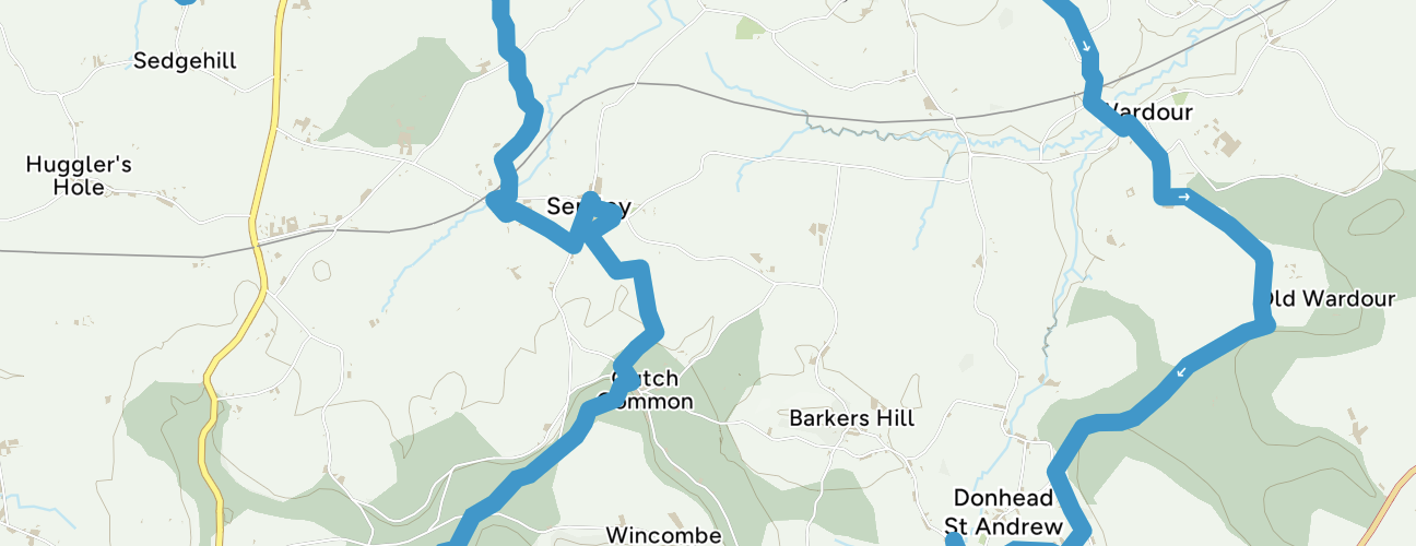
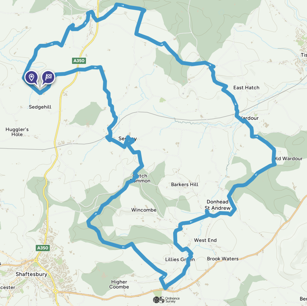
This is a walk which connects all the churches in the Benefice of St Bartholomew and Wardour Chapel using public footpaths and avoiding roads so far as possible. The route, clockwise from Sedgehill, goes via East Knoyle, Wardour, Donhead St Andrew, Donhead St Mary, Charlton, Semley and back to Sedgehill. As it is about 22 miles, it is suggested that people might like to treat it as a project to be completed over a number of separate days starting and ending wherever convenient. For details on each section of the walk, please scroll to the bottom of this page.
Ride+Stride
The plan is to launch the walk for the Ride + Stride day on 14th September 2024 which is in aid of the Wiltshire Historic Churches Trust and your chosen church (this has been much advertised separately for more details). Ride + Stride is an annual event which is held annually on the second Saturday of September. For further details, visit the WHCT website
Sponsorship forms can be requested by emailing Revd Kate or contacting your Churchwarden. Our hope is that people will get sponsored to walk with friends between any chosen number of our churches. Proceeds are shared equally with the Trust which deserves to be supported. At St Catherine’s Church, Sedgehill, WHCT have recently awarded us a grant towards our vestry wall repairs.
14th September 2024
Obviously, those participating in Ride + Stride will wish to choose what sections to walk in terms of what most appeals and at times most convenient. However, if you would like to join me for all or part of what I plan to do, I would be delighted.
My plan is to walk that part of the Way clockwise from Donhead St Andrew to Sedgehill via Donhead St Mary, Charlton and Semley. A rewarding but shorter section would be to meet us and start at Charlton. The rough distances and times of all the sections are shown below. I suggest that we start promptly at 9.00am at Donhead St Andrew which would put us at Charlton for a comfortable 10.30am departure. We would arrive at Semley at c12.45pm where I suggest that we have a BYO picnic with the lovely Semley Village Stores as a good option for provisions or even a beer at the Bennet Arms! For those who would just like to walk in the afternoon, I suggest that we might set off at 2.00pm which would get us to Sedgehill at c3.30pm. Those with energy to spare can carry on to East Knoyle.
If you would like to join me please let me know (contact details below) and we can make a WhatsApp Group for the day.
St Bartholomew’s Way is intended to be a year-round resource for the Benefice and the aim and concept of the walk is not purely for Ride + Stride. It is hoped it will be an additional means for us to appreciate our respective churches and the wonderful countryside in which they are set. In due course, we hope to produce a booklet. In the meantime, it is hoped that these pages on the website will assist any walking plans. This Introduction is followed by separate pages for each section of the walk. The route details should be regarded as work in progress (for example, some footpaths that we would like to use are currently inaccessible) and any feedback would be very welcome.
Guidance
The best way to follow the route is by using the Ordnance Survey maps. Most of the walk is shown on the OS Explorer 118 1:25000 scale map (2.5 inches to 1 mile). The exception is a small part of the walk leading to and from East Knoyle which is on the OS Explorer 143 map. These maps show the footpaths and it is recommended that you use them or, better still, with an Ordnance Survey subscription (which provides access to all OS maps online and access to an App on your smartphone) you can follow the links provided in the route descriptions.
Extracts from these maps are provided here online using an OS Media Licence with the restriction that they may not be printed or copied. You will need, therefore, to trace the route shown onto your own OS map.
Unless you are planning to do the whole walk in one go, you will need to plan your transport as the sections are point to point and there is no reliable or convenient public transport available. The best way to do this is to walk with others and plant a car at each end of the proposed sections that you will be doing. Parking is possible near all the churches and where helpful is described in the relevant sections.
St Bartholomew’s Way mainly follows footpaths although there are a few unavoidable roads. The footpaths are not always well signed and some signs are well-hidden which is why a map is a pre-requisite. The ground can be rough, very muddy in wet weather and there are some hills! I can attest to the fact that it is possible to take a dog but there are some stiles which they will have to jump or be lifted over (my Springer Spaniel managed to jump them all unlike her owner). It goes without saying that dogs should be under control and there are parts of the walk where they should be on leads where there are animals or we are crossing shooting land.
| No. | Section | Miles | Time (approx.) |
| 1 | Sedgehill to East Knoyle | 2.60 | 1h |
| 2 | East Knoyle to Wardour Chapel | 6.20 | 2h45m |
| 3 | Wardour Chapel to Donhead St Andrew | 3.00 | 1h20m |
| 4 | Donhead St Andrew to Donhead St Mary | 0.75 | 20m |
| 5 | Donhead St Mary to Charlton | 2.00 | 50m |
| 6 | Charlton to Semley | 4.50 | 2h10m |
| 7 | Semley to Sedgehill | 3.20 | 1h25m |
If anyone would like further information or can add to the guidance in these notes please do let me know.
Simon Chalwin
Mob. 07785 515630
Email schalwin@gmail.com